running & cycling

Wednesday, January 31, 2007

January 20, 2007
Shut-in/Mountains-to-Sea Run

Saturday morning was quite cold. This always presents a dilemma. We'd be climbing into higher altitudes but during the climb much warmth would be created. So, how many layers are enough? Since this was an out and back run, extra clothing could be ditched and retrieved on the return.

Sarah Almodovar had organized the run. Her original intent was to do a double Shut-in. She had run the upper half the previous week and the weather would be a bit sketchy so the run was modified to the lower half of Shut-in and the Mountains-to-Sea trail on the other side of the French Broad river. Since I'd recently run a double Shut-in, I certainly understood not wanting to run the same section two weeks in a row. This would be my first excursion on the trail since early November. It beat me up a good bit and I had no desire to conquer it again for some time.

Two guys came down from Boone to join us. Doug was a veteran runner who I met during a bicycle ride in the high country, and who had run the Shut-in race four times before. Dennis is a newby to this trail. I stayed with everyone until the first big climb, a whole 1/4 mile into the run. From there I was on my own until I met them on their return.

I was not loving the trail this day. I simply couldn't run as much of it as I'd wanted. Some days it just doesn't click. I'm used to this and when this happens, I just take it easy and take in more of the scenery. Long, slow distance is an important part of training and I'd get in my share of the slow distance.

The turn around point was at nine miles. I met the others at about 8 1/2 miles and turned back when I saw them. I then led the group for a while until I ran myself to exhaustion. They went ahead and I was on my own again. I don't mind getting behind but I don't like it when people have to wait an extended period of time for me. As I approached a steep hill, I made the decision to skip it and follow the Parkway for a mile or so. I thought this would close the gap and maybe I would actually catch someone by doing this but the plan backfired. I got around the hill climb but I actually added some distance.

Passing some hikers, I inquired how far ahead they were and they said about three or four minutes so I was pleased. I made it to the parking lot and loaded up food for the next out and back leg.

Crossing the bridge over the river, we were greeted by Adam Hill and his group home kids. He was taking them on a hike and brought us a bounty of sustenance in the form of bagels and pastries. We chatted a bit and went on our way. I stayed with them for a good while. After crossing the highway, there was a short, steep downhill where I hammered down and went way out in front. The downhill was also my downfall. I was exhausted after it and I fell far behind.

I just took it easy again from that point. I passed the tree where I surprised a bear on the Pitchell run. I was even closer to it than I'd remembered. Hendersonville road seemed like a good place to turn around so I wouldn't be caught lagging behind for the rest of the run. Sarah, Doug and Dennis went to Sweeten Creek road and turned back. They would run 30 1/2 miles while I would run about 27. My body was very worn down from training and I was nursing an ankle sprain from last week so 27 was more than I expected to cover.

I managed to stay ahead until the last mile. We made it back to the cars and decided to partake in the obligatory postrun burrito. The Lucky Otter was the spot this time. Local brew, a couple of margaritas and burritos rounded out our day.

Raging Bull

January 13, 2007
Mt. Mitchell Training Run

'Twas just a typical January morning in the Carolinas, 50 degrees and sunny. I was hosting a training run on a portion of the Mitchell Challenge course. I had just lugged 4 1/2 gallons up a 20+% grade for about a kilometer and readied myself for a 20+ mile run. 14 runners participated.

I handed out maps and soon we were on our way. I ran with Annette Bednosky early on because I knew she'd be ahead of me very soon. I soon lagged behind just about everybody. I spent most of my time running with Steve Parrish. We discussed ecobuilding as he is a home builder. The trail is a fantastic place to get to know someone. I only wish I could stay with more runners so I could converse more. If I push hard enough to stay with the faster runners, I breathe too heavy to carry on a conversation.

The turn around point was over ten miles in where a side trail summited Rocky Knob. We saw a runner who just came down from the top but he said no one was up there. They had all run past the trail and continued to the Parkway, another 2+ miles further. Steve and I hiked to the overlook. Breathtaking is a term that is a bit cliched but it truly was breathtaking and incredibly clear. One of these times, I'll remember my camera.

We headed back toward the start, thinking we'd gone far enough, then I had a change of heart and wanted to meet up with those who went to the Parkway. We didn't have to go too far. I mentioned the summit hike and a few guys decided to head up. Matt Kirk, Chris Shields and Brad Smythe and I cruised up and enjoyed the viewshed. Humor flowed freely and we simply had a fantasic time.

We leisurely ran back on the Toll road, taking in the sites along the way. When we got to the aid spot, the decision was made to cut the run a bit short and head down Appalachian Way. This is a dirt road but it is heinously steep. I went into Beduhnasaurus mode and hammered it. I ran so hard that my IT band just about gave out. I also sprained my ankle in the process but it was unbeknownst to me until the following day when my ankle swelled up and I limped noticeably.

At the parking lot, we could here screams coming from the stream. Cold water is outstanding after a long run but it causes me pain. Adam Hill and Matt would live in the water if they could. Rob Rikoon had the stuff we needed. Cold PBR's were waiting for us. I'm not much of a fan of PBR but wow, did they ever hit the spot. Of course, we had to find some more brew and burritos, which taste so fine after 22 miles, so five of us headed to Camino's in Black Mountain.

Raging Bull

Friday, January 05, 2007

January 1, 2007
Smokies Big Creek Adventure Run

The rains came for two days before the run. Normally, this wouldn't matter but the course included fords, one of them through Big Creek. We should have been singing tunes from "The Sound of Music". We would climb every mountain and ford every stream. This was another of Adam Hill's fun/adventure runs, with the emphasis on adventure.

We started up the Baxter Creek trail. I do mean up, as the trail climbs 4,000 feet over 6.2 miles. I couldn't keep up with the others. Eventually, Matt Kirk took pity on me and dropped back. Near the top, the clouds broke but it was quite dark as we we found ourselves in the midst of a dense, lush spruce forest. The sun's rays peaked through the trees like spotlights on a stage.

We all met up at the Mt. Sterling fire tower. It was a harrowing climb to the top but well worth it for the crystal clear views. Of course we had to pose for the obligatory picture.

The descent from Mt. Sterling was rocky with tricky footing. This is the one area where I excel. I rumbled by everyone and garnered a new nickname. I was dubbed "Beduhn-a-saurus Rex" for my aggressive downhill style. If only I could be that aggressive on the uphills.

The downhill didn't last forever and soon I again found myself at the back of the pack. I thought I saw a little green creature with a cane. I couldn't understand the cane when he was such a badass jedi. We were running through Dagobah on the top of a 5,000 foot mountain. The rains filled the horse beaten trail. Lush vegetation surrounded either side and an X-wing fighter hovered nearby.

A trail junction brought us together again. But soon I dropped back yet again. I tried to keep up with Sarah Almodovar and Mohammed Idlibi, but my effort was in vain. They slowly crept out of site and I was alone. This got frustrating, thinking I was holding everybody up. The trail grew wetter and wetter and I was trying to keep my feet dry until we came upon the fords. I forgot to bring my light and grew concerned over whether I'd make it through by nightfall. This apprehension was illfound and it quickly went away when I met up with the group again, as they were partaking in some nappage in the sun.

I was imbued with a newfound energy and led the pack to the next junction. This bit had some tricky footing and I ran well over the rooty, rocky terrain. A sign with bold, red letters greeted us-"Do not use Gunter Fork in times of high water". We took a picture of it and promptly ignored the warning. This was, after all, an adventure run.

Gunter Fork trail descends rapidly and is a bit off camber. Maintaining the proper balance of speed and agility presents quite a challenge. We all cruised the downhill at a rapid pace. Mohammed almost slid off the mountain but maintained his balance. The trail started to level out a bit after two miles and we were greeted with a wonder of nature.

Before us was quite a sight to behold! An enormous waterfall spilled over 150 foot rock face in front of us. To the left was a 50 foot waterfall. We had to ford our first stream. The water was cold but it didn't take long to get across. This was followed immediately by another ford. We stopped a while to admire the cascade.

The trail leveled out a bit and we really got to know Gunter Fork. We crossed again and again and the crossings grew wider. There were more fords than a used car dealership. We drove a chevy to the levy but the levy was flooded. The last crossing of the fork was quite difficult. The current was strong and the whitewater prevented sight to the bottom. I barely made it without tumbling. We'll call this one "Mustang".

Finally, the last ford was upon us. We'll call this one "Thunderbird". A human chain stretched part way across it. Adam was anchored in the middle helping everyone else across. Carl Laniak retreated to help out as well. The current was considerably stronger than the last one. This was Big Creek, with easily twice as much water as Gunter Fork. I opted out of the human chain and went upstream a bit to avoid the current. Still waters run deep and it got up to my waist but the footing was solid and I kept my upper body dry.

From there, it was all pretty level. We followed the river but the next two crossings had bridges. I sang off pitch to entertain myself as everyone had run ahead again. I'd heard about Midnight Hole and how it was a must to swim there. It was January 1st, but I knew that wouldn't stop Adam, Matt and Carl from swimming. I'd had enough water already. Mohammed also got in on the action. Sarah, Steve and I had enough sense to opt out. There's even a video of those nuts jumping off an eight foot high rock into the frigid stream.

The trail from Midnight Hole to the finish was fast and furious. We all had a blast despite spending so much time in the water.

What run is complete without a fine meal of pizza? Most of us headed out to Asheville Pizza and Brewing and chowed down on some mondo sized delish za's. That was a fine way to spend New Year's Day. It wasn't quite an ultra but the 23 miles certainly felt like it.

Raging Bull

December 16, 2006
ALTAR (Art Loeb Trail Adventure Run)

This is more than just a run. It's a party. It's comraderie. It's ALTAR. The Art Loeb Trail Adventure Run takes place near the winter solstice. The challenge is to make the traverse in the daylight hours. This is a speed hike more than it is a run.

Matt Kirk rented a "cabin" for us. This cabin was far more luxurious than any of our homes. Good times were had over dinner and afterward. Adam Hill led a singalong and we all swapped war stories of life on the trail. Wonderful brew from French Broad Brewery was had in abundance.

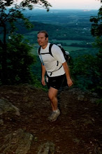
We were greeted with a balmy 29 degrees at the trailhead. The obligatory photos were taken and 24 of us commenced on the epic journey. The first half mile is flat-- pancake flat. We wouldn't see much more of this flat nonsense.

The trail crossed a bridge and it was up, up, up. I started out near the front and stayed there far longer than I'd anticipated. I was leading the main running pack for about a mile. I heard Adam talking behind me and I knew I shouldn't be leading this pack. I stepped aside and let everyone pass and then resumed at a more relaxed pace.

I ran pretty much alone for several miles. I ran with Mike Day off and on and with David Kirk and Sammy Pangle. They went ahead and I ran around Cedar Rock by myself. Cedar Rock is a large rock face. The trail skirts just below the exposed granite. The temptation to explore the face was definitely there but time was of the essence as I still had many more miles to go. I passed a hunter shortly after Cedar Rock.

The trail reached a shelter and I headed past it down a faint trail. This didn't seem worn enough so I turned back toward the shelter to look at the map but then Mike, Rob Rikoon and India Coleman came running and took a right up the hill so I followed.

The first aid stop was at 12+ miles. It wound up taking 3 1/2 hours to cover that distance. The problem was that we hadn't even hit the steep climbs yet. This was just a warmup and it took almost as long as the Shut-in race. We found out that some runners had already dropped out.

After leaving the aid station, the trail climbed steadily at a reasonable rate for a half mile. Then it got ridiculous. The grade increased dramatically to about 30% for a good stretch. I was exhausted just going at a slow hiking pace. I couldn't keep up with Rob and India but I could still hear their voices.

Eventually we all made it to Pilot Rock. The view was 360 degrees and we could see nearly to the starting point and nearly to the finish. It was still a good ways to the Parkway, which would mark the point just before the end of the primary climb.

Since Pilot was a pinnacle, we had a steep descent down the other side. That just meant more climbing to make up for the lost altitude. On the climb, we experienced leaves. We'd heard about foot deep sections of leaves but that sounded a bit far fetched. The leaves got deeper as we climbed. Some steps would result in knee deep leaves. Getting off the trail didn't help much either. Leaves were everywhere.

Finally, after nearly 6 hours, we crossed the Parkway. But we still weren't done climbing. A 26% grade greeted us on the other side. We were now in a spruce/fir forest so it was quite scenic. I just had to keep moving and eventually things would get easier. There was relief when we connected to the Mountains to Sea trail. I was lagging behind but I didn't care because the 7,000 foot climb was now over.

The second aid station had some extra people, as a few runners who dropped out helped. One group never showed up at the first station and they eventually took forest roads back to the start. That meant that we were likely the last runners still on the trail. I took off ahead of Rob and India to get a head start on the next climb. I saw someone ahead of me on the mountain. It was Sammy, and he waited for me to catch up to him. This section is the highlight of the run. Black Balsam is a bald mountain with views everywhere. You can see all the way to Mt. Mitchell, 80+ miles away by trail. Nearly the entire Pitchell route is visible. It doesn't seem possible to believe it can be traversed in one day when you look at it.

I had finally recovered from the climb but then another problem popped up. I made a rookie mistake by eating something I'd never tried before on a run. I consumed too much dried fruit and it was doing a number on my intestinal tract. This plagued me for the rest of the run.

We ran a few more balds and then entered the Shining Rock wilderness. There would no longer be any markings along the trail. Despite the wilderness tag, this was the easiest section. Unfortunately, I couldn't run for more than 50 yards at a time. Sammy stayed back with me so I wouldn't have to do the last nine miles by myself. We came upon a confusing intersection and chose the proper route. We hollered to Rob and India and they retraced their steps to the proper trail. They could have easily headed north instead of west and wound up way off course.

We never saw Shining Rock. The confusing trail led to it in a roundabout way. I'd hiked to it several years ago. The abundance of white quartz is striking. There is so much of it protruding from the mountaintop. Our trail skirted the summit and led to a section called the narrows. Sheer drops of a thousand feet slant down either side. We heard voices ahead and were surprised to find the main pack of runners hanging out on a rock outcropping. We weren't as far back as we thought. Granted, they had taken in their share of scenery along the way but it was certainly a boost to see them all.

We didn't stay together for long on the descent. The group broke up but we only had four miles left to the finish. I had planned on ascending Cold Mountain. After all of that climbing and the intestinal pains, I made the decision that there was no freakin' way I was going to do that. It's another 1,000 feet of climb and it would put me finishing in the dark as well.

I slowly descended toward the finish, staying just behind a few runners. Uwharrie, Matt's dog and an ultrarunner in her own right, disappeared for a while. She made her presence known behind us and we called for her but she didn't come running. I turned back to make sure she wasn't hurt. I called for her and finally spotted her just off the trail across a ravine. She started to run down the ravine. I motioned for her to follow the trail and she responded. She was okay but perhaps hallucinating a bit. She stayed with me only briefly and then ran ahead on the trail. I was again alone but still moving slowly but steadily.

The camp was coming within earshot. Hoots and hollers were heard as several runners splashed in the river. I strolled in after 10 hours, relieved to be finished. A campfire roared and soup was ready for us. Homemade Chili would be on the menu when we got back to the cabin.

Sunday brunch stretched out over two hours. Afterward, I moseyed over to Looking Glass Rock and did a little recovery hike/run. From the top, much of the Art Loeb route was visible. Pilot Rock looked every bit as steep as it felt the day before. Black Balsam looked like the top of the world. Another run was in the books. The images grow more pleasant after the fact as the memories of pain and fatigue quickly fade away. Next year, I will do Cold Mountain as well.

Raging Bull