December 29, 2007 - January 1, 2008
Bartram Four Day Stage Adventure Run
Matt Kirk devised this traverse of the entire Bartram trail, starting in Georgia, and finishing at the Nantahala Outdoor Center in North Carolina, after adding in some miles on the AT. Two home bases were procured to alleviate the logistics.
Matt, Mohammed Idlibi, Uwharrie and I were the only takers. Matt, Uwharrie and I headed down to Georgia, where we met Mohammed.
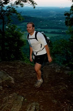
Saturday's run started along the Chatooga River right at the South Carolina/Georgia border. After posing for start pictures, we headed down the trail. I dropped back early and adopted a very comfortable pace. The trail went through pine forest and remained fairly level.
I was surprised to see Matt and Uwharrie. They were at a confusing junction. I ran with them for a half mile or so and then they went on ahead. Six hours was the goal for this 23 mile stretch. It would be the easiest day but with three more to go, I was in no hurry.
Eventually, the hills became larger and there was a fair amount of ridge running. The views were nice and I could see what was in store for the next day. An extended downhill brought me to Warwoman Dell, a picnic area, which meant 19 miles were done.
The climb out passed a very nice waterfall. About a mile further, it became quite lush with a waterfall/sluice next to the trail. After a confusing circular hitch in the trail, an even more spectacular waterfall showed itself. Past it, trail markers were everywhere. The yellow markers were ubiquitous and mind boggling. I sorted them out and found the correct direction.
The last two miles contained much more climbing than expected. I filled up my bladder with some fresh spring water and continued to the gap where a side trail brought me down. Matt and Mohammed had already finished and driven back to the start to retrieve Mo's truck. Day one was over without incident. We covered 23 miles with about 4,000 feet of climb. Saturday's meal was Italian at restaurant near the hotel.
Day two's forecast was for rain throughout the day. I volunteered to run support and wisely so. This was the longest and most difficult day. Matt and Mo headed back up the side trail to hit Bartram just before daybreak. I had time to lounge around the hotel room. Uwharrie stayed with me in the morning.
I met them on Route 106. They both showed up earlier than I'd expected. I picked up some Subway for them. I paced Mo for about a mile up Scaly Mountain and then headed back to the car to go to the finish. It was still raining a bit but I got out and headed up a ways and then back to the car. Matt had picked up U-Dog at 106 and they came in again sooner than expected.
I waited a while and then headed back up to greet Mohammed. I hadn't dressed properly so I returned. The next time I had a better jacket, which actually kept me dry. I saw Mo a quarter mile up and we headed down. Mo hopped in a stream to soak. Matt and Mo covered 33 miles with over 8300 feet of climb. I stayed comfortable and did 5 miles. Sunday's meal was Chinese in Clayton, GA.
Monday's stage began west of Franklin and finished at Appletree Campground. I drove to the finish and ran back toward them. I was making good time, going opposite of a stretch I'd just done three weeks prior. The climb up from Nantahala Lake was difficult but the trail was in much better shape than it had been. I met Matt and U-Dog about four miles from Wayah Bald. I met Mo about two miles later.
Wayah Bald was clear but I'd forgotten my light so I couldn't spend too much time there. The trail was more technical on Wayah. I filled up in a spring and readied for the descent. The trail dropped in a hurry. Two long switchbacks led to a very steep ridgeline descent. It was a rollercoaster the rest of the day. I climbed and descended mountain after mountain. The trail almost always went over the peaks. I was cursing the trail builders.
One spot forked and I went the right way first but saw no blazes. The other way was devoid of blazes as well. I trusted my instincts and followed the first path. I'd turned back to early. This was the correct way.
The mountains kept coming. Eventually, I hit a cove and I knew I'd be done soon. A hiker told me it was about a mile to go. I still had daylight but wouldn't make it back to Nantahala before nightfall. I kept looking at the sun and it seemed to stay still for several hours. It appeared to be at the same spot all afternoon until I enetered the cove. Satge 3 was 23 miles at 6,600 feet of gain. The New Year's Eve meal was Mexican in Bryson City. Adam Hill called to see how the run was going and to warn us of a winter storm heading our way.
The Nantahala cabin was extremely cozy and we each had our own room. None of us was interested in staying up to ring in the new year.
For the final day, I dropped them off and went to the rafting put-in. I decided to continue where I'd left off on the previous Bartram run. The bike path was flat but as soon as the trail crossed the river and the road, it started climbing. There would be seven creek crossings so I wore Gore-tex hikers. It was wise since I slid off a rock during the first crossing. It was below freezing and the Gore-tex kept my foot from becoming drenched but some water got in over the top.
The trail climbed very steeply from there and then headed back toward the creek for another crossing. This one went better but the third one required shimmying across and ice covered log. Stream crossings are nice in the summer but on January first with a winter storm on the way, they're not quite so appealing.
The trail rose steeply through the rocks. Footing was difficult at times and I took it easy as a result. I would find out later that Uwharrie had been tracking me when she was on this section with Matt.
The climb seemed endless and I continued to rock hop streams. The trail finally attained some high altitude and then leveled off a bit. I welcomed the moderate climbing. However, several footbridges now appeared on the trail. They were over dry runs, which added insult to injury since there were none over the actual streams.
The final stream crossing led to a wide trail which crossed an old roadbed. I saw on the map that the next section would be straight up and it was. The climb to Little Bald was dastardly steep. Fortunately, Cheoah wasn't much higher. The trail intersected with the AT and went to Cheoah Bald.
The Bald didn't disappoint. Vast strtches of grass grew down from the summit and the view on the north side went on for 40 miles or more. The advantage of running/hiking in January is that the air is clear and the best views can be had. On the downside, it can be quite a different world at 5,000 feet. The temperature was below freezing, verified by an icy bite tube and the wind chill was in the single digits. Running shorts don't provide much protection in those conditions so I didn't admire the view for long.
The trail descended Cheoah in a hurry, for which I was quite pleased. The AT tended to straddle the mountains, skipping most of the peaks. This was a welcome relief from the countless peak topping of the day before.
After exiting the ridgeline, it really warmed up and the wind became a nonfactor. I stopped to talk to a hiker for a bit after surprising him. I told him another runner would be by soon and that was an accurate statement. I figured Matt and U-Dog weren't far behind, despite the extra mileage they were covering.
I came to a road, checked the map and saw it was just over a mile to the river. I picked up my pace and completed the journey. The cabin was a full 20 yards off the AT. Just 14 minutes after I arrived, Matt showed up. I went down to the Nantahala with U-Dog and then we picked up the start vehicle. By the time we got back, Mo had already completed his journey as well. Then it was down to the river for a soak in the frigid water.
I covered 65 miles over the four days with about 17,000 feet of climb while Matt and Mohammed both completed the full 105, with 25,500 feet of climb. I was very impressed with the way they held up. A stage run was a new experience for all of us.
Mo headed out Tuesday evening and we headed to Bryson City for pizza. The winter storm hit during the night and the ride home took three hours, instead of the usual hour and a half.
B-Rex
posted by raging bull @ 12:57 PM
0 comments
![]()