March 15, 2008
Foothills Trail 76 mile run
I thought I might be a bit crazy for attempting this beast of a run so early in the year and without much training for it. Uwharrie was the only ultra I'd completed thus far in the new year. One ultra was cut short when I took a wrong turn. One had been cut short by bad knees and one had been cut short by bronchitis or something similar.
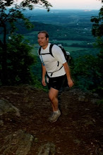
Matt and I headed down to Greenville, SC to Byron Backer's place. Rich Lilly and Brian Kistner were there as well. The plan was to get in a short nap and then head to the trailhead for a midnight start. I didn't get much of a nap in but soon it was time to go. Irene Backer drove us to Table Rock State Park. We had to walk on the road a good while to get to the trail.
We started at 12:20 am. The trail climbed gently along a stream. The rocks were wet but we were just hiking so it didn't seem to be a problem. I went ahead and Matt came along. I figured if I had a decent lead early, then I might stay with the group through the first section.
On a small stream crossing, I stepped on a wet rock at a 45 degree angle. My foot slipped and my knee hit the rock with plenty of force. I walked it off, hobbling away but it hurt something awful.
The others caught up when I had to wait at an intersection. I was choosing the wrong path so it was a good idea to wait. We climbed steeply and summited Pinnacle Mountain. The top was exposed granite slickrock which required all fours to navigate. Two tents were pitched at the top and we woke up the inhabitants.
I slid frequently on the descent so I fell behind everybody else. I'd planned on taking it easy due to an overuse knee issue but had added an additional knee issue when I fell so caution was the course of action on the downhills, especially at night.
The view from the top was of a sea of clouds. A half moon illuminated the cloudscape while other mountains poked through to form islands.
Interesting rock formations greeted me on the descent. I stepped on a stick with one foot and impaled my other ankle. This was a pain that would soon fade but it had a major impact briefly.
I caught sight of a headlamp on the coming switchbacks but that was the only time I'd see a light on the trail. Approaching Rocky Bottom, a thriving metropolis of over a dozen people, I could see the lights of a camp. It seemed awfully close but was actually quite far off. I crossed a road and became baffled because I did not recognize it. I confused it with a previous road crossing on the map and thought I was at the start of the Laurel Valley section.
Continuing, the trail got leveled out and then became rocky. A camper had pitched his tent right smack in the middle of the trail. I awoke him and pressed on to 178.
This was where Byron had dropped some food and drinks for us. I grabbed a fair amount of food but foolishly left some. Since I was the last one through, I should have taken every last morsel and later regretted not having done so.
The Laurel Valley section was the one I was familiar with. It's about 35 miles but feels like 40+. The first half isn't too bad but the second half is a beast. It would be 35 miles until I saw another soul. I started up the steps to the single track. Looking down at the road, I regretted not hopping on it just to save several minutes.
Before I knew it, I was passing the first of many waterfalls. The morning light was creeping in and the temperature was perfect for running. Approaching the second waterfall, it started to sprinkle and then it began raining in earnest. I put on my garbage bag, which really does work quite well as a raincoat and at almost zero weight and space, and settled in for the first major climb of the LV section.
The trail plateaus for a while and then heads down to Lake Jocassee. The lake wasn't where it was supposed to be. One channel had water but the rest of the lake bed had tall grass growing in it. The drought had lowered the level considerably.
After crossing a bridge over the first major stream, I removed the garbage bag and noticed a small animal hopping about a log. It was a woodcock, a fairly common but rarely seen bird with a rotund body and a very long, curved beak. It hops along like a rabbit.
Plenty more climbs awaited me. This one would be the steepest. The trail climbs up a knife ridge, using hundreds of steps pressed into the dirt. It's a rollercoaster climb until you're sent straight down an express elevator of 200 godawful steep steps until you're spit out at a campground with trails shooting in all directions.
A flast section runs along the lake, where old stumps are visible withinthe tall grass. For the next 15 miles, it's nothing but climbing and descending. The second half of the section is significantly more difficult than the first. The climbs get progressively tougher and they really wear down a body. Adding to the difficulty is the rain, which started up again, but this time with much more force.
I passed some backpackers, two of which were having a miserable time as they were attempting to backpack the entire. It was nice to see people. Shortly thereafter, the skies opened up. The hard, driving rain soaked the trail in the low spots. I'd been battling within my psyche whether or not to continue past Whitewater Falls. That is the 50 mile point. The trail trends downhill after the Falls but it's still nearly 30 more miles to the finish.
The long bridges over the larger rivers were quite slick from the rain. After crossing the Toxaway River, There is a steep staircase which exhausted me. I was wishing I was nearer the finish but had to suck it up and continue because my day was far from over.
The distance between rivers looks shorter on the map than in reality. Lightning and thunder were making themselves known in the distance. They don't bother me unless the strikes get within a half mile. They soon got a bit closer.
On the descent to the Horsepasture River, they got a little close for comfort. I slowly and steadily made my way across the bridge and experienced near simultaneity of lighning and thunder. This meant it was within a hundred yards, perhaps even closer. I was crossing a body of water with local strikes raining down upon me.
I was a bit shaken and opted to seek the shelter of a large rock outcropping just across the river. While I was there, the rain turned its power up a few notches and it came down much harder.
After cowering for a good while, I pressed on through the driving rain. Much of the trail turned into a stream. I had still had miles to go but was wishing that it soon would be over. The slog through the lighning continued. The last few hills before the flat section seemed much easier than usual. The summer heat makes them real killers but not so with cooler weather.
I came to the last campsite sooner than anticipated and knew there was just one small descent before the Whitewater River. It was still a slow go on the flat mile but I just had two miles to go. There was no logical reason to continue on into the night with more rain on the way.
The waterfalls at the finish were roaring with an intensity I'd never seen before! They had to be appreciated for a spell but I didn't everyone waiting on me any longer than necessary. I slowly made the rock crossing and the last climb up to the steps. The steps are tough at the end but they signal the final half mile so they don't hurt as much as the ones in the middle of the run.
It was almost 6:00 when I finally made it to the shelter. 17 1/2 hours later the ordeal was over. Byron and Rich had the sense to call it a day as well. Brian K continued a bit further and Matt completed the journey for the second time, remaining the only know runner to have completed the entire trail at one time. I figured it'd take another nine or ten hours for me to finish it.
We had a nice cabin at the finish. November will see another attempt and barring rough weather, it should be successful.
B-Rex
posted by raging bull @ 9:55 AM
![]()

1 Comments:
Hello. This post is likeable, and your blog is very interesting, congratulations :-). I will add in my blogroll =). If possible gives a last there on my blog, it is about the OLED, I hope you enjoy. The address is http://oled-brasil.blogspot.com. A hug.
Post a Comment
<< Home