January 12,19,26, 2008
Fun Runs
Standing Indian Loop
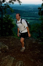
Thirteen of us headed west to the Franklin area for an AT loop. This was supposed to be about a 27 miler. I fell to the back of the pack on the road and made it to the trail alright. I made the correct turn and followed the blue blazes. After a while, I expected to cross a road. I finally did come to a trail junction on an old road bed. Unfortunately, all four directions were blazed blue.
After milling around for a while, deciding upon which route to take, I chose the steepest trail, thinking it would get me to the AT the fastest. My map was of little help as the trail configuration was not present on it.
Continuing, I still thought I was on the right track. When I finally got to another intersection with a sign, I discovered I was way off track. An old road bed led to the AT, but it was nearly four miles away and I was already behind so I made the decision to form my own loop.
I had taken the Park Ridge connector, which was not shown on the map but which was blazed blue just like the trail I was supposed to take. I took Park Ridge up to the intersection and then headed back down Park Creek. This trail had nemerous stream crossings but managed to keep my feet dry with some fancy footwork on logs and rocks.
I passed the start of Park Ridge and headed back up the original trail to see where I made my wrong turn. It was then back to the cars where I would wait for a good while. My loop was only 14 miles while everyone else was doing 27. Fortunately, Drew had a comforter in the back of his truck so I bundled up in the parking lot and waited.
Drew Shelfer was the first one in and soon after, Matt Kirk and Andrew Moore came in. After a while, Adam Hill, Rick Gray and myself headed down the Wasilik Poplar trail. WE have pictures of us hugging the enormous beast. It's a tuliptree with a circumference of 27 feet at abh and about 35 feet at the ground!
On the way back up, I tried to beat Adam by cutting off a long switchback. I Barkleyed my way up but the 40% grade wore me out.
Toll Road
Eleven intrepid souls showed up to tackle a good portion of the Mitchell Challenge/Blk Mtn Marathon Course on Saturday. The trails were mostly snow covered with spots of ice. The air was cold and it snowed for much of the run. The course would be run under realistic race conditions.
We weren't the only group out there. A group of women was encountered early as well as two groups of friends, including Mike Piercy and Jon Snow in one, Mark and Anne Lundblad and Mike Mason in another,and a solo runner, Kevin Lane.
Rick and Tammy Gray, along with Josh Helms came from Johnson City and Nick Whited came down from Virginia. Adam ran a portion and Jason Hayward & Tsali, Wendy Wright, Sarah, John and William ran as well. I hope I got people's names right since there were several I hadn't met before. It was a mix of newbies and veterans of the upcoming race. Six of us headed to Camino's to fill our bellies afterward.
This Saturday is the Seven Sisters fun run/trek. It'll be 14 miles of mostly gnarly and steep single track. The total climb will be 4300 feet. Bring your cameras because it is one of the most scenic courses anywhere. Expect it to take at least four hours to complete. Same meeting place, the parking lot by Lake Susan in Montreat. We'll meet around 9:00 and head out by 9:30.
Brian Beduhn (B-Rex)
Seven Sisters Summit
Five runners completed the Seven Sisters Summit loop in Montreat Saturday. Wendy Wright, Chris Shields, Jason and Elizabeth Hayward, Tsali and I tortured our muscles on some sick climbs and fast downhills. The trails were in good shape with some snow and ice on the north slopes.
This time of year affords clear views. The first lookout is on Lookout Mountain. It's a rock scramble to the top and gives an excellent vantage point for the entire route. The course looks very difficult from there and it doesn't disappoint in its ability to challenge.
After some ups and downs on East Ridge, Trestle allows for some recovery time. The easy part doesn't last however, and soon it's up the Greybeard Trail. After passing a back country shelter, we encounter Walkers Knob, with its stellar lookout point. All of Montreat and Black Mountain are in full view as are Mt. Pisgah and the Black Balsams and numerous other ranges.
Greybeard Summit looms in the distance as we continue our ascent. At 5400 feet, Greybeard provides a panoramic view. This is one of the better vantage points in the east. We spend some time on top but it does get chilly so we head down West Ridge.
West Ridge is a moderately descending trail but is punctuated with numerous rock outcroppings and presents a challenge for even nimble footed runners. There is some scrambling as we traverse the Seven Sisters.
Big Piney Ridge takes us back to Montreat. After a quick drop, it levels out and opens up to a granite exposure. The sun did its job and warmed it up nicely so we relaxed a good while here. A bomber of a dropoff takes us back to a road, which leads back to the start.The total distance is just over 14 miles, but the run climbs 4300 feet!
B-Rex
posted by raging bull @ 1:45 PM
![]()

0 Comments:
Post a Comment
<< Home