September 8, 2007
TR and More in 24
Table Rock to Montreat Trail Run
I hadn’t run in the Linville Gorge before. I’d hiked a portion of the route and recalled it was very difficult terrain even for just hiking. It would be a slow go much of the day, but a fantastic way to spend my birthday.
We met for a prerace meeting at Adam’s and then headed east to Black Mountain for burritos at Camino’s. The finish point was to be in Montreat, so we left vehicles there and carpooled to the gorge. The drive concluded with an endless journey through a veritable sandstorm of white dirt. The road was so dry from the drought that all of the vehicles became caked with dust. Rear windows were completely covered with over a quarter inch. Wipers had to be employed constantly. It looked like we had evacuated the site of a volcanic eruption.
We weren’t the only ones looking to camp in the area. The weather was fantastic and fortunately so, since we camped out under the stars. After getting situated on the solid rock atop Table Rock, we got to enjoy a couple of light shows. The fabled Brown Mountain lights made an appearance. These lights have been recorded for hundreds of years and appear as glowing balls of light often darting around and making their way up the mountain. Scientists still debate how they are formed, but they are most certainly not illusions or swamp gas.
One light flared brilliantly and was joined by another intermittently. They didn’t dance around for us but they did entertain and had us guessing if they were headlamps of hikers but they were way too bright for that. A couple of shooting stars lit up the sky as did the Milky Way. Getting away from the city lights, nebulae and the Andromeda galaxy were observable by the naked eye.
Drew brought up some Bud tallboys, which Adam and I enjoyed with him. Most of the others were nodding off but we stayed up a bit and observed the city lights in the distance. Soon it was time to go to sleep. The 5:00 wake up time wasn’t far off.
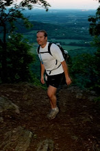
We made our way down the mountain and dropped off our sleeping gear. I led the pack up the trail briefly and then dropped back. Soon, all but one runner had gone ahead. India and I were in the back and we decided it was more important to pace ourselves than it was to stay with the others.
Running through the Chimneys is quite challenging. It was still a bit dark and the use of hands is required to negotiate the terrain. The trail is a bit deceiving. The area is a mecca for climbers and routes go off in all directions. The trail isn’t always marked at regular intervals. We came to a spot where the trail appeared to stop. We retreated, thinking we’d made a wrong turn, taking several of these climbing routes but none continued for long. Finally finding a course marking, we retraced the dead end trail to the spot where we turned back. It was a bit overgrown, but we had been on course the first time.
We had a long descent through some Carolina Hemlocks through rattlesnake territory. It was still early so no snakes showed themselves. The sun came up with a pink and then an orange hue.
Late spring saw a tremendous wildfire in the gorge. Entire trees had been scorched and the trail was nonexistent for good stretches. The fires had left a barren, almost lunar type landscape. Everything was blackened except for a small white coloration where the trail had been.
We continued to take it at an easy pace. We left the scorched area and entered a very rocky landscape. This was the trail type where small rocks were on top of other rocks, making it rather treacherous to run with any speed. The trail took a hard right, which would have been very easy to miss as another one continued straight. I headed down very quickly and waited for India at the bottom.
We soon found ourselves amongst more scorched earth. This time the trail was not apparent. Every bit of ground was blackened and all of the trees with markings were blackened as well. We had to search for footprints to find our way. A logging road was visible ahead so we took that down to the river. We heard voices coming from that direction. We got there and found Rob, who was searching for the trail. Having been forewarned about the confusing Linville River crossing, I knew it would be challenging to find the trail. We followed trail markings upstream but it seemed like a closed trail with numerous branches across it.
We chose the old trail and crossed where the markings ran out. The water wasn’t even knee deep. On the other side, no markings were present. It was bushwhacking time but we came across a dirt road in short order. It had markings so we followed it until a singletrack trail led off uphill. This was also marked but faintly so. It spilled onto a wide trail, which we followed downhill—the wrong way. Adam and Sarah came running up and we were all confused. They should have been way ahead of us but had waited where they crossed downstream.
We turned around and began a long, hot climb up to some peak. This was a steep go. We didn’t try to keep up with Adam, Sarah or Rob. The weather really started to heat up so we stopped occasionally to rest. The peak afforded nice views but we didn’t stay. Fluids were low and we needed to get to the aid stop. I downed two cokes and loaded my Camelbak with ice for the next leg.
We had some downhill for a good while and then climbed up to a dirt road. After a couple of miles, the road gave way to a steep trail. This was another slow climb to the top, where we could see the general area for the next aid stop. It appeared as though it was only 2-3 miles away, but it was much, much further.
The descent involved 40+ switchbacks. It was around 90 degrees at this point, so we even took it easy on the downhill to avoid overheating. Thankfully, there were several areas with large, shady boulders where we could cool off. When we reached a dirt road, I thought we were approaching the aid stop. I was considerably mistaken.
We hit another single track section, leading us to some train tracks. As we crossed them, I heard some noise and around the bend came a train. At this point, at least one runner had followed the tracks and had to ford the Catawba River. There was a new footbridge for the trail, which we utilized and then followed a dirt road. I misread a trail turn and took a different road. Realizing my mistake, I looked at the map and it appeared that we were on a shortcut so I opted to continue. After a while, we went through private land and back to the Catawba. It was time to backtrack, wasting time and fluids. We still had a long way to go until route 221.
Another singletrack stretch led up over what appeared to be a small hill but it kept going up. I ran out of fluid and had to bum off India. It felt as if heatstroke wasn’t far off. The sun relentlessly pounded us as we entered onto a dirt road. We followed this road down the hill, running through the sunny spots and taking our time in the shade. We finally popped out at 221, where we were greeted by Matthew and several others. We had a plan to get a ride to the next aid station so we wouldn’t be so far behind. Then we learned that two runners dropped and two others were only 30 minutes ahead of us. Everyone had planned to drop after getting to the Parkway.
We rested a good while before continuing. The 13 mile climb to the Parkway rose gently on an old road bed. It soon gave way to a very fast and smooth extended downhill. The stream at the bottom would be the last water we’d see for hours so we soaked a bit. We hopped on a grassy stretch of road bed until a sharp turn to the right, which we almost went past. This was an arduous climb, which leveled out occasionally but continued up for some time. It had cooled off slightly, but I faced overheating issues on the steep climb. We rested a few times here.
The trail continued on a mostly inclined plane until it took a sharp left. This was also easy to miss. The run was billed as an adventure run and it was. We followed trail markings but in some stretches they were absent. Turns weren’t always well marked and trail locations had been moved, not to mention the spots where the trail had been obliterated by fire.
I thought we only had a few more miles to go judging by time, but a quick look at the map showed we still had 6+ miles to go. Every section took substantially longer than expected. The heat had taken its toll. I questioned the accuracy of the published distances. The terrain was extremely difficult in places but it was broken up with some very runnable sections.
Continuing forward, daylight started to fade. Soon, we’d need headlamps. It was getting dark and we heard some rustling about 40 yards off the trail. There was a good chance it was a small bear. A little later, just after our headlamps were switched on, there was no question this time. A larger bear was just 20 yards to our right. It took off quickly. Shortly afterward, I missed stepping on a snake by about an inch. It slithered to the edge of the trail. In a moment of sheer genius, I stood over it to see what kind it was. There was no rattle but its head was viper shaped. It bore copper like markings on a grayish base. I didn’t expect to see a copperhead on top of a mountain but that’s what it was.
The remaining three miles would have to be traversed in the dark. I ran into a sharp stick but it didn’t do much damage. I let out a sharp cry but the pain soon went away. I ran out of fluid and just a couple of minutes later, I found a cold bottle of Gatorade in the middle of the trail. Jon Snow had placed it there for us and we were thankful for it.
The sound of automobiles gave us some hope that we were about through but it was all a tease. The trail skirted the parkway and then shot away from it. Soon, we did here a voice responding to our headlamps. It was Adam hootin’ and hollarin’ and we responded in kind. Everyone else had already stopped and gone home. I was feeling fantastic since it had cooled off. India was feeling all right as well. I would’ve continued if anyone else had but I also had no problem with calling it a day. It had taken 15+ hours to cover 39 miles of trail and with wrong turns, about 41. It felt more like 50. I still question the published distance.
I expended some excess energy by sprinting along the Parkway. Then we filled up on some food. As I sat down in the car, my inner thigh/hamstring broke out in some serious pain. I had to walk it off for some time. The full distance was nearly 60 miles and would make an outstanding run for a cooler day.
posted by raging bull @ 12:25 PM
![]()

0 Comments:
Post a Comment
<< Home